|
FICTION
- The Egyptian Queen Cleopatra
was fond of traveling
the Nile with her suitors, Julius Caesar and Mark Antony. The Pharaoh took her
life in 30BC, using a poison asp. A secret society are developing super
humans, using advanced nano-computers and cloning technology. Their
backer is a German
occultist, looking to reincarnate Cleopatra, using the DNA from her
mummy.
But nobody has found her tomb. A DNA expert and ocean
adventurer discovers that this group have found
the sarcophagus underwater at Alexandria.
The
Nile is a major north-flowing river in northeastern Africa. It flows into the Mediterranean Sea. The longest river in Africa, it has historically been considered
to be the longest river in the world, though this has been contested by research suggesting that the Amazon River is slightly longer. The Nile is amongst the smallest of the major world rivers by measure of cubic metres flowing annually.
The
river
is about 6,650 km (4,130 mi)
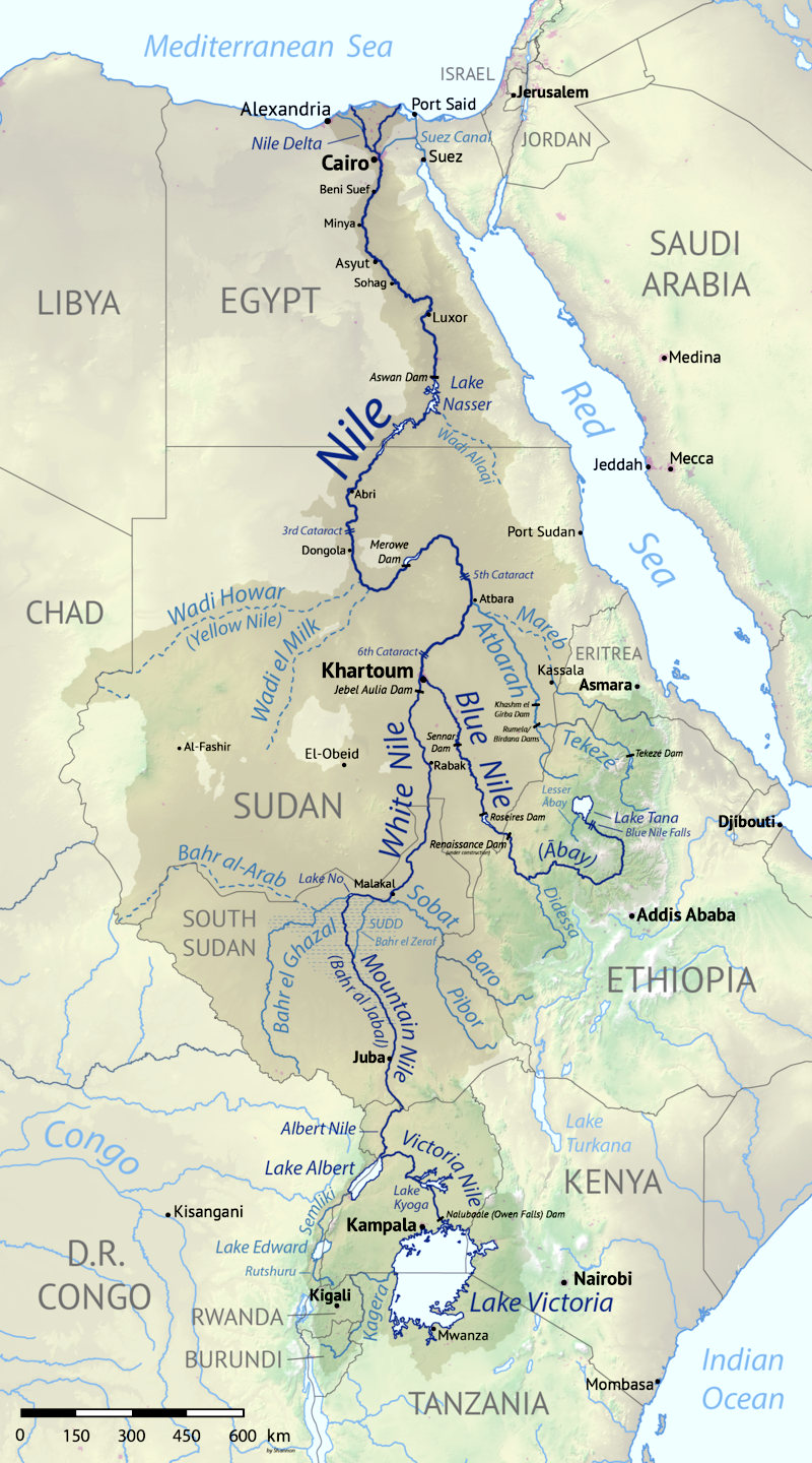
long. Its drainage basin covers eleven countries: Tanzania, Uganda, Rwanda, Burundi, the Democratic Republic of the Congo, Kenya, Ethiopia, Eritrea, South Sudan, Republic of the Sudan, and Egypt. In particular, the Nile is the primary water source of Egypt, Sudan and South Sudan. Additionally, the Nile is an important economic river, supporting agriculture and fishing.
The Nile has two major tributaries – the White Nile, which begins at Jinja, Lake Victoria, and the Blue Nile. The White Nile is traditionally considered to be the headwaters stream. However, the Blue Nile is the source of most of the water of Nile downstream, containing 80% of the water and silt. The White Nile is longer and rises in the Great Lakes region. It begins from Uganda Lake Victoria, Uganda and South Sudan. The Blue Nile begins at Lake Tana in Ethiopia and flows into Sudan from the southeast. The two rivers meet at the Sudanese capital of Khartoum.
The northern section of the river flows north almost entirely through the Sudanese desert to Egypt, where Cairo is located on its large delta, and the river flows into the
Mediterranean Sea at
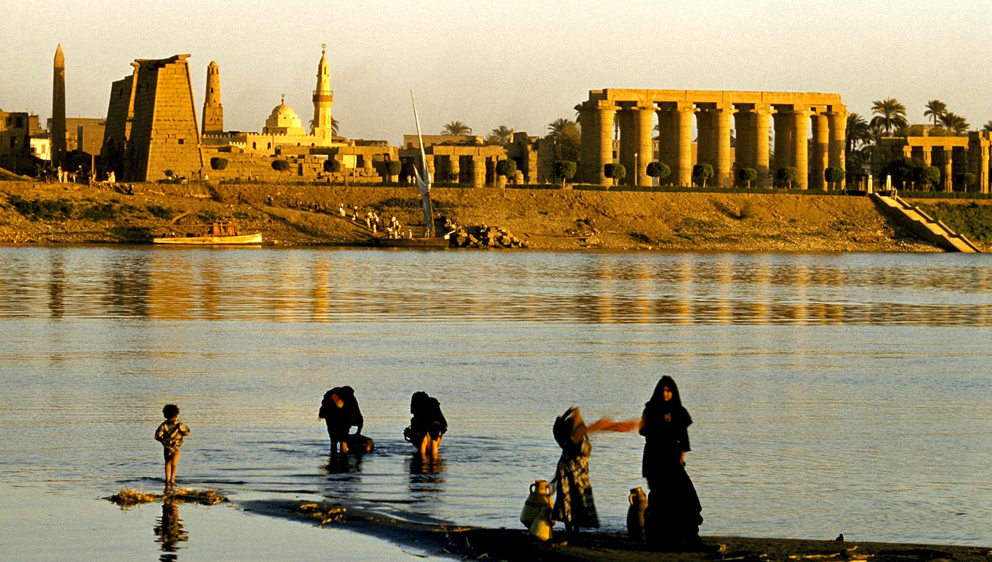
Alexandria. Egyptian civilization and Sudanese kingdoms have depended on the river and its annual flooding since ancient times. Most of the population and cities of Egypt lie along those parts of the Nile valley north of Aswan dam. Nearly all the cultural and historical sites of Ancient Egypt developed and are found along river banks.
With a total length of about 6,650 km (4,130 mi)[a] between the region of Lake Victoria and the Mediterranean Sea, the Nile is among the longest rivers on Earth. The drainage basin of the Nile covers 3,254,555 square kilometers (1,256,591 sq mi), about 10% of the area of Africa. Compared to other major rivers, though, the Nile carries little water (5% of the Congo River, for example). The Nile basin is complex, and because of this, the discharge at any given point along the mainstem depends on many factors including weather, diversions, evaporation and evapotranspiration, and groundwater flow.
Upstream from Khartoum (to the south), the river is known as the White Nile, a term also used in a limited sense to describe the section between Lake No and Khartoum. At Khartoum, the river is joined by the Blue Nile. The White Nile starts in equatorial East Africa, and the Blue Nile begins in Ethiopia. Both branches are on the western flanks of the East African Rift.
NUTRIENTS TO BUILD AN EMPIRE
The soil of the Nile River delta between El Qâhira (Cairo) and the Mediterranean Sea is rich in nutrients, due to the large silt deposits the Nile leaves behind as it flows into the sea. The banks of the Nile all along its vast length contain rich soil as well, thanks to annual flooding that deposits silt. From space, the contrast between the Nile's lush green river banks and the barren desert through which it flows is obvious.
For millennia, much of Egypt's food has been cultivated in the Nile delta region. Ancient Egyptians developed irrigation methods to increase the amount of land they could use for crops and support a thriving population. Beans, cotton, wheat, and flax were important and abundant crops that could be easily stored and traded.
The Nile River delta was also an ideal growing location for the papyrus plant. Ancient Egyptians used the papyrus plant in many ways, such as making cloth, boxes, and rope, but by far its most important use was in making paper. Besides using the river's natural resources for themselves and trading them with others, early Egyptians also used the river for bathing, drinking, recreation, and transportation.
Today, 95 percent of Egyptians live within a few kilometers of the Nile. Canals bring water from the Nile to irrigate farms and support cities. The Nile supports agriculture and fishing. The Nile also has served as an important transportation route for thousands of years. Today, some residents of El Qâhira (Cairo) have begun using private speed boats, water taxis, or ferries to avoid crowded streets. Dams, such as the Aswân High Dam in Egypt, have been built to help to tame the river and provide a source of hydroelectric power.
However, the silt and sediment that used to flow north, enriching the soil and building the delta, is now building up behind the dam instead. Instead of growing in size through the soil deposits, the delta is now shrinking due to erosion along the Mediterranean Sea. In addition, routine annual flooding no longer occurs along parts of the Nile. These floods were necessary to flush and clean the water of human and agricultural waste. As a result, the water is becoming more polluted.
The
ancient Egyptians cut down trees that secured the soil for agriculture.
They used the trees for construction and to make plaster for Pyramid
building. In removing the binding roots, agricultural production reduced. The inhabitants utilized the Nile to adapt to the changing environment. Instead of roaming the land, they saw the opportunity the Nile provided them through agriculture. Similar to how the Mayans developed Neolithic techniques through maize, beans, and squash in the tropical climate of Guatemalan rainforests, early Egyptians were able to grow wheat, beans, and cotton on the banks of the Nile. By determining when the Nile flooded, the river proved to be a sustainable way to live life.
The flooding of the Nile was not a perfect occurrence. This gave rise to the belief in the gods and a highly stratified social structure. At the top of the social structure were gods such as Ra and Osiris because the Egyptians believed that they controlled the universe. The Egyptians tried their best to please the gods because if they were happy, then the Nile would flood producing an abundance of crops and preventing famine. After the gods came the pharaohs in social status. The Egyptian people believed the pharaoh to be a god in mortal form. They had absolute power over the dominion which required protection through the help of government officials and soldiers. The rest of the people’s status went in the order of scribes, merchants, artisans, farmers, and finally slaves.
This social stratification was necessary for a civilization as large as ancient Egypt to function. Slaves were utilized to build infrastructure, farmers produced the food for the society, and the other social levels contributed by either governing, defending, or producing commodities for the civilization. Social mobility was possible in ancient Egypt though. Sending sons to schools to learn how to read and write could make it possible for them to become a scribe, boosting social status.
Ancient Egyptian civilization was created and greatly influenced by the Nile River. The flooding of the Nile was sustainable but not perfectly reliable, creating the belief in gods and social stratification.
Ancient Egyptians developed highly complex irrigation methods to maximize the effect of the Nile waters. When the Nile overflowed in mid summer, Egyptians diverted the waters through the use of canals and dams. As the water seeped into the farm land, rich deposits of silt ensured a bountiful harvest.
Egyptians developed methods of predicting the impact of yearly inundations, recording yearly water levels. The Old Testament story of Joseph in Egypt, most probably as a Vizier to the Pharaoh, illustrates Egyptian concerns regarding the flow of the Nile and its impact on future harvests. Although the story is not corroborated by other historical sources, there were documented periods when Egypt, through careful planning, had sufficient wheat and barley while other areas of the ancient world were experiencing famine conditions.
During the period or season of “inundation,” when Egypt became a virtual sea, the Egyptians used their time to work on state building projects. During the Old Kingdom, the pyramids were constructed through the labor of Egyptians, usually during periods when the Nile flooded its banks. In the Middle Kingdom, flood periods produced canals, temples, and other official edifices that served the entire community.
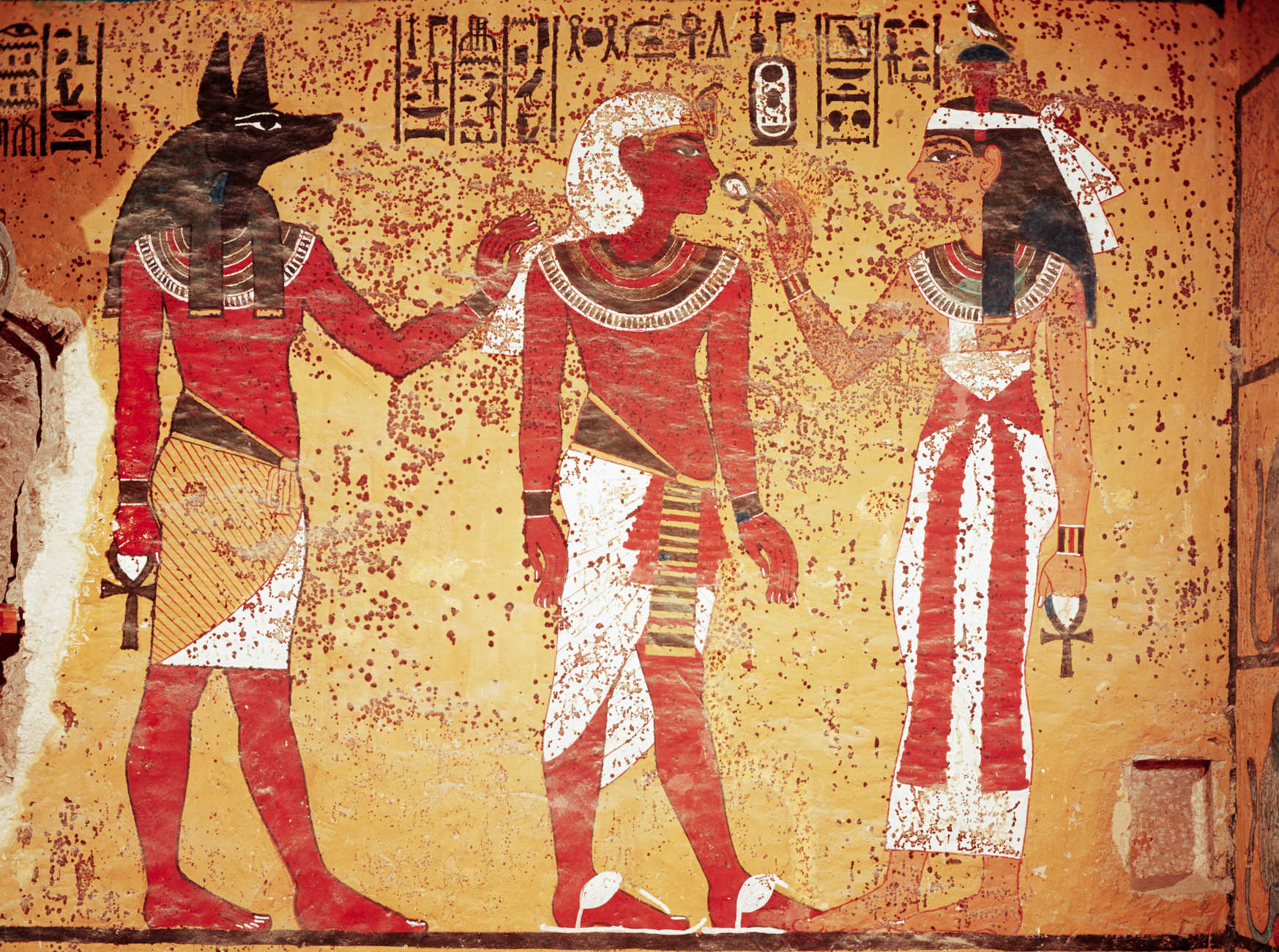
Osiris was the god who taught the Egyptians agriculture. The overflowing of Egypt’s banks by the Nile also recreated the Egyptian creation story which reminded every Egyptian that the Nile waters were linked to life. According to one of the Pyramid Texts, the Spirit of the Nile declares, “Canal of happiness will be the name of this canal as it floods the fields with plenty.” Interestingly, in the Old Testament story of the Exodus, one of the “plagues” upon Egypt was the turning of the Nile waters into blood. The Old Testament symbolism should not be lost. While the Nile was sacred to the Egyptians, blood, associated with the remission of sins, was a vital part of Hebrew belief.
The Nile River provided sustenance to Egypt for around 3000 years. In 332 BC, Alexander the Great conquered Egypt and Ptolemaic period of Macedonian rule began.
HISTORY
The Nile (iteru in Ancient Egyptian) has been the lifeline of civilization in Egypt since the Stone Age, with most of the population and all of the cities of Egypt resting along those parts of the Nile valley lying north of Aswan. However, the Nile used to run much more westerly through what is now Wadi Hamim and Wadi al Maqar in Libya and flow into the Gulf of Sidra. As sea level rose at the end of the most recent ice age, the stream which is now the northern Nile pirated the ancestral Nile near Asyut. This change in climate also led to the creation of the current Sahara desert, around 3400 BC.
The Greek historian Herodotus wrote that "Egypt was the gift of the Nile". An unending source of sustenance, it played a crucial role in the development of Egyptian civilization. Because the river overflowed its banks annually and deposited new layers of silt, the surrounding land was very fertile. The Ancient Egyptians cultivated and traded wheat, flax, papyrus and other crops around the Nile. Wheat was a crucial crop in the famine-plagued Middle East. This trading system secured Egypt's diplomatic relationships with other countries and contributed to economic stability. Far-reaching trade has been carried on along the Nile since ancient times. A tune, Hymn to the Nile, was created and sung by the ancient Egyptian peoples about the flooding of the Nile River and all of the miracles it brought to Ancient Egyptian civilization.
Water buffalo were introduced from Asia and the Assyrians introduced camels in the 7th century BC. These animals were killed for meat and were domesticated and used for ploughing—or in the camels' case, carriage. Water was vital to both people and livestock. The Nile was also a convenient and efficient means of transportation for people and goods.
The Nile was also an important part of ancient Egyptian spiritual life. Hapi was the god of the annual floods, and both he and the pharaoh were thought to control the flooding. The Nile was considered to be a causeway from life to death and the afterlife. The east was thought of as a place of birth and growth, and the west was considered the place of death, as the god Ra, the Sun, underwent birth, death, and resurrection each day as he crossed the sky. Thus, all tombs were west of the Nile, because the Egyptians believed that in order to enter the afterlife, they had to be buried on the side that symbolized death.
As the Nile was such an important factor in Egyptian life, the ancient calendar was even based on the three cycles of the Nile. These seasons, each consisting of four months of thirty days each, were called Akhet, Peret, and Shemu. Akhet, which means inundation, was the time of the year when the Nile flooded, leaving several layers of fertile soil behind, aiding in agricultural growth. Peret was the growing season, and Shemu, the last season, was the harvest season when there were no rains.
THE SOURCE OF THE NILE
The ancients mistakenly believed that the Niger River represented the upper reaches of the White Nile. For example, Pliny the Elder wrote that the Nile had its origins "in a mountain of lower Mauretania", flowed above ground for "many days" distance, then went underground, reappeared as a large lake in the territories of the Masaesyli, then sank again below the desert to flow underground "for a distance of 20 days' journey till it reaches the nearest Ethiopians." A merchant named Diogenes reported that the Nile's water attracted game such as buffalo.
Modern exploration of the Nile basin began with the conquest of the northern and central Sudan by the Ottoman viceroy of Egypt, Muhammad Ali, and his sons from 1821 onward. As a result of this, the Blue Nile was known as far as its exit from the Ethiopian foothills and the White Nile as far as the mouth of the Sobat River. Three expeditions under a Turkish officer, Selim Bimbashi, were made between 1839 and 1842, and two got to the point about 30 kilometres (20 miles) beyond the present port of Juba, where the country rises and rapids make navigation very difficult.
Lake Victoria was first sighted by Europeans in 1858 when British explorer John Hanning Speke reached its southern shore while traveling with Richard Francis Burton to explore central Africa and locate the great lakes. Believing he had found the source of the Nile on seeing this "vast expanse of open water" for the first time, Speke named the lake after the then Queen of the United Kingdom. Burton, recovering from illness and resting further south on the shores of Lake Tanganyika, was outraged that Speke claimed to have proved his discovery to be the true source of the Nile when Burton regarded this as still unsettled. A very public quarrel ensued, which sparked a great deal of intense debate within the scientific community and interest by other explorers keen to either confirm or refute Speke's discovery. British explorer and missionary David Livingstone pushed too far west and entered the Congo River system instead. It was ultimately Welsh-American explorer Henry Morton Stanley who confirmed Speke's discovery, circumnavigating Lake Victoria and reporting the great outflow at Ripon Falls on the lake's northern shore.
European involvement in Egypt goes back to the time of Napoleon. Laird Shipyard of Liverpool sent an iron steamer to the Nile in the 1830s. With the completion of the Suez Canal and the British takeover of Egypt in 1882, more British river steamers followed.
The Nile is the area's natural navigation channel, giving access to Khartoum and Sudan by steamer. The Siege of Khartoum was broken with purpose-built sternwheelers shipped from England and steamed up the river to retake the city. After this came regular steam navigation of the river. With British presence in Egypt in World War I and the inter-war years, river steamers provided both security and sightseeing to the Pyramids and Thebes. Steam navigation remained integral to the two countries as late as 1962. Sudan steamer traffic was a lifeline as few railways or roads were built in that country. Most paddle steamers have been retired to shorefront service, but modern diesel tourist boats remain on the river.
SKY
DECEMBER 2017 - According to the Helmholtz Centre for Environmental Research in
Leipzig, the Yangtze was the worst offender, reference research published in the journal Environmental Science & Technology.
This Chinese river carries up to 1.5 million tonnes of plastic into the sea every year. In contrast, the Thames
in the UK puts 18 tonnes of plastic into the ocean.
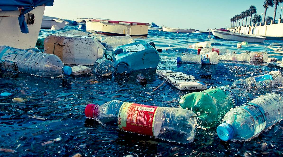
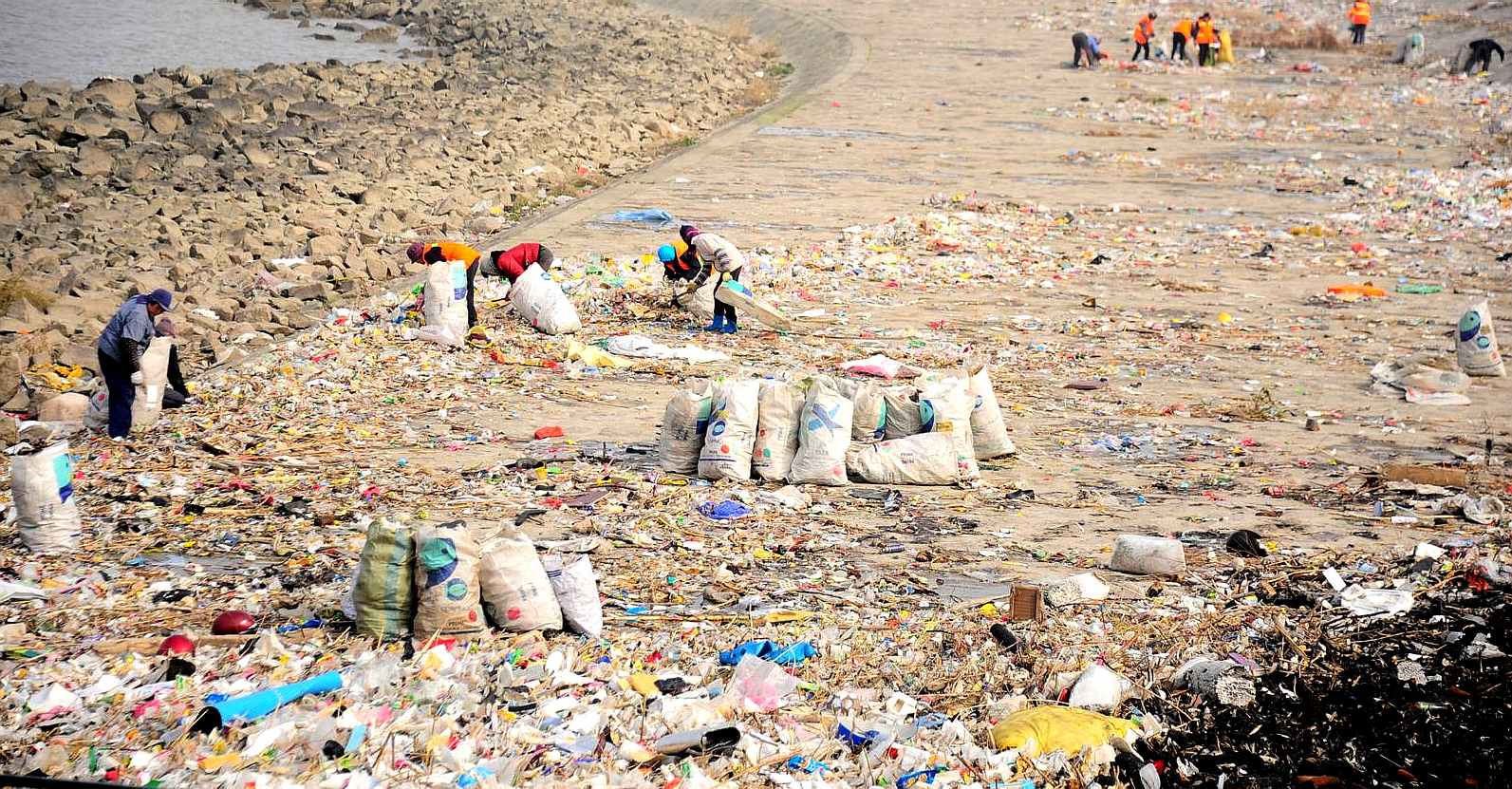
POLLUTION
Around
ninety percent (90%) of plastics in the ocean comes from just 10 rivers.
Nine of these rivers are located in Asia and one of them borders Thailand.
The top 10 most polluted rivers in the world have one thing in common – they are located alongside large
human populations with poor waste management
(PWM) systems.
Every
year the world, produces 300 million tonnes of plastics, and 8.8 million tonnes of these are dumped into the oceans. That’s about 40 billion plastic
bottles, 100 billion single-use plastic bags, and 522 million personal care items.
If
you know a seriously polluted river, or one that should be a candidate on a
bigger list, please contact Cleaner
Ocean Foundation.
The
rivers noted, added to hundreds of other lesser contributors feed the five
ocean gyres to poison marine life and cover the seabed in a mountain of
plastic.
1.
North Atlantic Gyre 2.
South Atlantic Gyre 3.
Indian Ocean Gyre 4.
North Pacific Gyre 5.
South Pacific Gyre
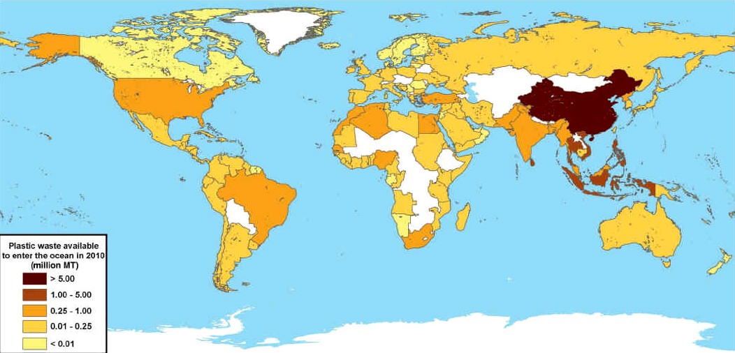
JAMBECK
2010 - Global map with each country shaded according to the estimated mass of mismanaged plastic waste [millions ofmetric tons (MT)] generated in 2010 by populations living within 50 km of the coast. 192 countries were considered. Countries not included in the study are shaded white.
AMAZON
- AMUR
- BRANTAS
- BURIGANGA
RIVER
- CITARUM
RIVER
- CONGO -
CROSS
- DANUBE
- DONG
- CUYAHOGA -
GANGA
- GANGES
- HAI
HE -
HANJIANG
- HUANGPU
- IMO
- INDUS
- IRRAWADDY
- IRTYSH
- RIVER
JORDAN
- KWA
IBO - LENA -
MAGDELENA
- RIVER
MANTANZA-RIACHUELO
MARILAO
- MEKONG -
MISSISSIPPI
RIVER
- NIGER -
THE
RIVER
NILE -
PARANA -
PASIG -
PROGO
- SARNO -
SERAYU
- SOLO
- TAMSUI
THAMES
- XI
- YAMUNA -
YANGTZE
RIVER
- YELLOW
- ZHUJIANG
PEARL
INDEX
- TOP 12
DIRTY DOZEN
LINKS
& REFERENCE
https://
|